"Accessibility for Inclusion" with National Federation of the Disabled - Nepal
Part-time Consultant, NFDN | Sep 2018
The Project:
Support the development and mobilization of a data collection app ‘NFDN Sleuth’ to leverage volunteers for collection accessibility data of 1200 places and make the data openly available via Open Street Map (OSM)
My Role:
Develop feature set
Wireframing
Train and support data collection volunteers
Upload the data on OSM
Tools I Used:
Google Workspace
SQL
Open Street Map (OSM)
Wheelmap.org
Introduction
National Federation of the Disabled Nepal (NFDN) is a NGO that represents more than 300 member organizations working for promoting the rights of disabled people throughout the country.
A random phone call to NFDN during an Assistive Technology hackathon led me to be a part-time consultant for the project “Accessibility for Inclusion”. The goal of my collaboration in the project was to input the wheelchair accessibility information of 1200 places in the Kathmandu valley on OpenStreetMap (OSM).
Tackling The Problem of Accessibility in Nepal
In Nepal, the lack of inclusive infrastructure in Kathmandu has hindered accessibility for people with mobility issues. The “Accessibility for Inclusion” project by NFDN aimed to address this by conducting accessibility audits of public places in the Kathmandu valley.
However, the project faced obstacles in the final stage when pressure was exerted to prevent the publication of the audit report by NFDN. As a result, a crowd-sourced open source alternative was adopted to salvage the project by leveraging OpenStreetMap.
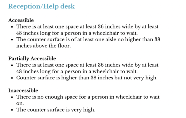
Underlying Accessibility Guidelines
In my role as a part-time consultant, I collaborated with the project’s architect to establish accessibility guidelines for data collection volunteers. Together, we set criteria for labeling various building components (entrances, elevators, ramps, reception/help desks, toilets, parking, signage, etc.) as accessible, partially accessible, and inaccessible.
By evaluating the accessibility of individual elements and their impact on the overall accessibility of the space, we categorized public places as wheelchair accessible, partially accessible, or inaccessible.
NFDN Sleuth - Data Collection App
The most difficult part for crowdsourcing the accessibility information of the public places was training the volunteers to enter the data to OpenStreetMap. The volunteers who had different abilities (with mobility, visual, and cognitive impairments) were unable to navigate through OSM.
In order to ease the data collection process, a separate easy-to-use mobile application ‘NFDN Sleuth’ was created using IONIC framework where special attention was made to make the interface extremely basic and easy-to-use. The application was tested for compatibility with read aloud functionality to make the app accessible for visually impaired volunteers.
The collected data from the application was later uploaded to OpenStreetMap and wheelmap.org.
Outcome
As the end of the project ‘Accessibility for Inclusion’, the wheelchair accessibility data of more than 1200 places in three districts – Kathmandu, Lalitpur, and Bhaktapur were added on OSM and wheelmap.org. The public places included in the project were hospitals, banks, malls, educational institutions, etc.
This data can, at present, be accessed via wheelmap.org which can be utilized by people with mobility impairments to look up the accessibility information on public places in their vicinity.